Distance: 16-17 miles (25-27km). High point: 230m (760ft) Upper Wyndcliff.
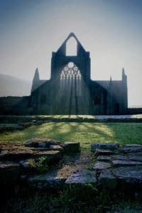
This section of the walk is almost entirely made up of paths through woodland along the celebrated lower Wye gorge. Expect dense woodland, narrow and sometimes steep paths emerging to viewpoints at Upper Wyndcliff and Whitestone. The walk also visits some attractive villages, most notably Tintern with its famous Abbey. The new route (as in the new Cicerone guide) of the WVW south of and through Tintern village is now waymarked. The old route is still available but the new route offers improved views across the Wye Valley and of the Abbey when approaching Tintern from the south and also passes the Tintern Limekilns. In the village the new route takes you down past the Abbey to the riverside before returning to the main road and gives the opportunity to see the heart of the village and use local facilities.The last few miles of the walk drop to the river, leaving the woods to follow the grassy banks of the Wye into Monmouth town.
Distance: 17-18 miles (27-29km). High point: 196m (647ft) Chase Wood.
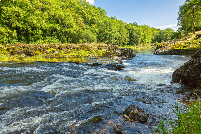
Starting in open fields this is an almost entirely level stretch of riverside walking following the meanders of the Wye and passing under the spectacular limestone cliffs and woodlands of the upper Wye gorge. The walk passes through busy Symonds Yat with its riverside pubs, boat trips and canoeists. Then, at just over half way to Ross, there’s an abrupt change of pace, the path climbing through steeply wooded hills and narrow valleys around Leys Hill and Howle Hill, before dropping into Ross from the heights of Chase Hill.
Please note: Lydbrook Bridge Closure and Diversion 2018
The route of the Wye Valley Walk (as shown on OS maps) is closed at Lydbrook bridge, (National Grid Ref: SO 587 176) due to the unsafe condition of this former railway bridge.
If walking upstream: walkers are advised to leave the Wye Valley Walk just east of Huntsham Hill (NGR 567 168) and follow the riverside footpath downstream to Huntsham Bridge (NGR 567 182), cross the Wye using this narrow road bridge and then, turning right, follow the riverside footpath upstream all the way to re-join the Wye Valley Walk at Lydbrook Bridge.
It is possible to remain on the south side of the river from Huntsham Hill and follow the Wye Valley Walk to the village of Lydbrook but as you cannot cross the river at Lydbrook the options between that point and Kerne Bridge necessitate walking along sections of the busy B4234 with no pavement.
If walking downstream: remain on the same side of the river at Welsh Bicknor (NGR 587 177) until reaching Huntsham Bridge (NGR 568 182), cross the river on this narrow road bridge and take the footpath on the left to walk upstream to re-join the Wye Valley Walk just east of Huntsham Hill (NGR 567 168).
Distance: 17-18 miles (27-29km). High point: 180m (594ft) Capler Camp.
The route changes from pastoral riverside walking to a hilly, up and down scramble through a patchwork of woodlands and fields forming part of the Woolhope Dome. There are also traditional Herefordshire orchards, black and white villages and mellow sandstone buildings. The final section of the walk follows the Wye floodplain into the City of Hereford, dominated by its fine cathedral where you can visit one of the world’s greatest mediaeval treasures, the Mappa Mundi.
Distance: 23 miles (36.8km). High Point: 318m (1,043ft) Merbach Hill.
This begins as a pastoral stretch, with an amble out of Hereford along the riverside, climbing a few gentle hills and passing through small mellow villages and orchards. After about 14 miles, the walk begins to change, starting a stiff climb up to the summit of Merbach Hill, then dropping again and following a series of less demanding hills, fields and dingles into the book town of Hay-on-Wye.
Distance: 21 miles (33.6km). High Point: Banc y Celyn 400m (1,312ft)
From the border town of Hay, famed for its bookshops and Literary Festival, a sequence of fields follow the increasingly boisterous Wye as the walk heads into Wales. There is the odd section of road with occasional climbs to bracken covered commons with views into the valley. In the final few miles, the walk leaves the river, crossing common land and small fields into Builth Wells.
Distance: 16½ miles (26.4km). High Point: Graig Allt-y-bont 380m (1,246ft)
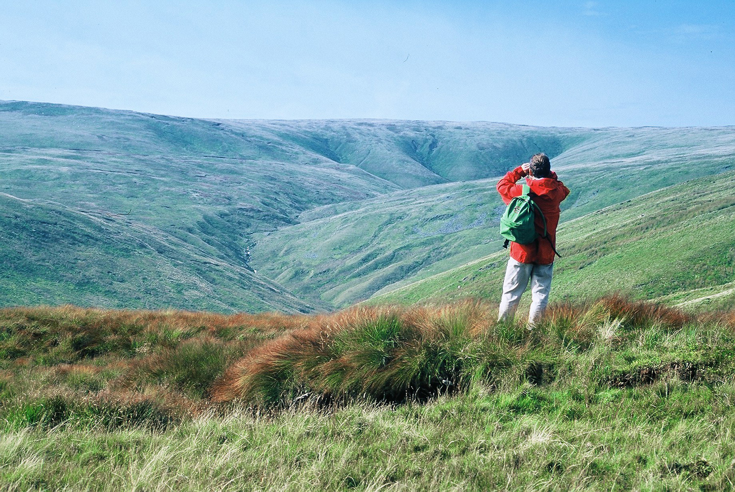
The character of the landscape begins to change, with a taste of the uplands to come. Initially, the walk is a riverside ramble through tree-lined avenues, fields, small woods and plantations. Towns and villages are fewer and further between. The Wye is turning to rapids and in the final four miles of the walk there’s a climb up to open, undulating moorland with views down from Carngafallt to Rhayader.
Distance: 24¼ miles (38.8km). High Point: 477m (1,575ft) Nantyhendy Hill.
The most exposed and mountainous section of the walk, it starts in small fields and woods but rises quickly into rugged hills with mountains rising ahead. There are drops to the rocky banks of the river and short stretches along narrow lanes and railway embankments, but the inevitable climb begins after about 10 miles at the Dernol Valley, drops down to Llangurig, then climbs again up the slopes of Plynlimon.